The SCAR GeoMAP (Geological Mapping Update of Antarctica) action group is an international effort to gather both rock and surficial deposit information and compile it into a modern GIS framework. It will depict ‘known geology’ of rock exposures, rather than ‘interpreted’ sub-ice features, and is aimed towards continent-wide perspectives and cross-discipline interrogation.
Why?
There are numerous, hard-copy, regional-scale geological maps of Antarctica that were developed last century. Many have been scanned, some have been georeferenced, but few are more than raster digital information. For the most part they are geologically reliable for defining bedrock geology (‘deep time’) but unfortunately they contain little representation of glacial geology. The maps have poor spatial reliability in the context of modern science (located by GPS and other satellite sensors), and the maps have not kept pace with the present importance of Antarctica’s role in climate change.
Background
Following publication of the New Zealand Geological Map and the South Victoria Land mapsheet in 2012, GNS Science launched an ambitious project to build a similar high-quality digital geological dataset covering the entire Antarctic continent. Enthusiasm and support was sought at the 2014 Open Science Conference in Auckland through formation of a SCAR Action Group.
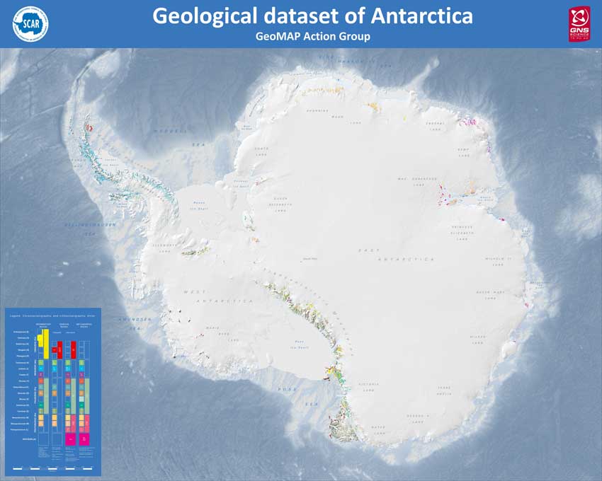
Five-years later, the first (beta-testing) version of GeoMAP (v.201907) was released at the ISAES XIII meeting, providing a modern geological GIS dataset describing exposed bedrock and surficial geology of Antarctica.
How?
Construction involved a ‘top-down’ work-stream, starting from a continent-scale, low density, attribute-poor dataset that has been added to and improved through multiple iterations. It involved capturing existing geological map data, refining its spatial reliability, then improving representation of glacial sequences and geomorphology. Feature classification and description rock and moraine polygons employ international GeoSciML data protocols to provide attribute-rich and queriable data; including bibliographic links to source maps and literature.
Around 95,000 polygons are now unified for use at 1:250000 scale, but locally have areas with higher spatial precision, founded on a mixed chronostratigraphic- and lithostratigraphic-based classification. There has been a specific focus on representation of glacial deposits because of their potential to contain records of ice fluctuations of relevance to climate change.
By Whom?
The project has involved principal collaborators from USA, Norway, Italy, UK, Australia, Russia and New Zealand, but includes contributions from at least 14 nations. Much of the manual work has been completed by an ‘engine room’ of 11 student volunteers, who visited New Zealand on SCAR or Witter supported internships or worked remotely by video-conferencing in return for supervision and GIS-training. Many others have provided advice, data and support. Visit the GeoMAP members page for more information.
Quality and Expected Use
As the dataset has been worked on, it has improved in both its geological interpretation and spatial accuracy. One of the hardest tasks has been, and still is, building consistency and capturing the local nuances of different interpretations available. There will undoubtedly be debate as to how well this has been achieved for v.201907, but there is full-expectation that it will continue to evolve and improve over time. As well as geological units, faults, and bibliographic sources there is a quality layer providing information on the attention various areas have received and the relative quality of the information provided (Scale Lowest=1 to Highest=5).
In many ways GeoMAP is like a spatial Wikipedia of Antarctic geology. It is unlikely to be a first port of call for specialists undertaking detailed research, but all the information is present to provide introductory overviews and bibliographic links to original work. There is potential to provide fresh perspectives, for example, through combined geological legends and interrogation of continent-wide time-space plots. GeoMap should be ideal for continent-wide perspectives and cross-discipline science.
Opportunity to Contribute
The next stage of work will involve reviewing and finalising GeoMAP for publication. It is expected GeoMAP v.201907 will undergo peer scrutiny, QA/QC and editing for full publication around mid-2020. The Action Group are looking for people to contribute their local knowledge, so please contact Simon Cox if you would like to contribute.
Terms of Reference for the Group
This group will facilitate an integrated programme to promote the capture of existing geological map data, update its spatial reliability, improve representation of glacial sequences and geomorphology, and enable data delivery via web-feature services.
Objectives
- Solicit wide international representation.
- Debate and decide on GIS-data structure and delivery mechanism:
- Debate the relative merit of a distributed database like OneGeology, versus a centralised database model;
- Ensure adopted process enables retention of academic and custodial rights (sovereignty) as/where necessary.
- Convert geological maps into GIS-databases and smart web feature services.
- Improve definition of glacial geology and geomorphology using satellite imagery and remote sensing, local age-dating studies.
- Find a host for web services, perhaps utilising Geoserver or ArcGIS Server, in WMS smart image form or in WFS feature form (utilising GeoSciML).
- Prepare paper outlining geological nomenclature and classification issues that arise.
- Highlight areas for targeted research and/or the need for new geological field work.
- Facilitate exchanges of early-career and other scientists with an interest in spatial representation of the geosphere.
GeoMAP publications
- GeoMAP Action Group Report 2019 In Sub-Group Reports 2019 16 September 2019
- SCAR EXCOM 2019 Paper 12: Report from Geosciences Group In SCAR EXCOM 2019, Plovdiv, Bulgaria 05 September 2019
- 2019 Poster of the GeoMAP dataset overlaying the REMA dataset In Geological Mapping Update of Antarctica (GeoMap) 17 July 2019
- Abstract of the 2019 poster of GeoMAP on REMA In Geological Mapping Update of Antarctica (GeoMap) 17 July 2019
- SCAR XXXV WP15: Geosciences Group (GSG) Report In XXXV SCAR Delegates 2018, Davos, Switzerland 20 September 2018
- SCAR EXCOM 2017 Paper 6: Report of Geosciences Group AND Geosciences Group Reports In SCAR EXCOM 2017, Brno, Czech Republic 02 August 2017
- SCAR GeoMap Powerpoint presentation In Geological Mapping Update of Antarctica (GeoMap) 19 January 2017
- SCAR XXXIV WP08b: Reports from Geosciences Action and Expert Groups In XXXIV SCAR Delegates 2016, Kuala Lumpur, Malaysia 30 August 2016
GeoMAP Presentation
“Towards a digital dataset of the Antarctic geosphere” (7.11 MB) – a Powerpoint presentation on the SCAR GeoMAP project, its work and the progress made up to 2016 in mapping the geosphere.
GeoMAP Newsletters
- GeoMAP Newsletter – 1 – Feburary 2016 In GeoMap Newsletter 01 February 2016
GeoMAP Workshop 2015
GeoMAP held a workshop at the XII ISAES Meeting in July 2015 called “Towards improved geological maps of Antarctica rocks and surficial deposits“:
- GeoMap Workshop 2015: Towards Improved Geological Maps of Antarctic Rocks and Surficial Deposits (Announcement)
- GeoMap Workshop 2015: Towards Improved Geological Maps of Antarctic Rocks and Surficial Deposits – Summary
- GeoMap Workshop 2015: Towards Improved Geological Maps of Antarctic Rocks and Surficial Deposits (Slides and Notes)